
Urban Regeneration through Relocation-based Methods
Achieving Urban Regeneration through Relocation-based Methods
~ A brief introduction of the Land Readjustment and Urban Renewal programs in Japan ~
- This website aims to introduce the mechanisms of the Land Readjustment program and Urban Renewal program, both of which have played significant roles in urban regeneration in Japan. We offer a comparative explanation with the globally popular Land Acquisition method.
- Designed for first-time readers in this field, the website prioritizes clarity and ease of understanding. Consequently, some parts may not be entirely accurate, and we kindly ask for your understanding on this.
- For a deeper and more precise understanding of both programs, please refer to the linked reference sites at the end of the page.
- We hope that readers will enhance their understanding of these programs and find them useful.


Introduction
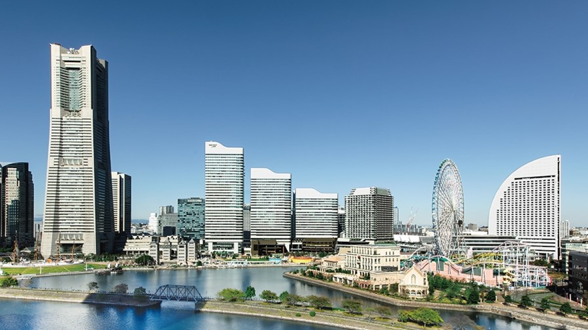
Japan has been facing numerous urban challenges due to the significant urban influx during the rapid economic growth in the 1960’s.
Examples include:
- Insufficient infrastructure, such as roads and parks
- A shortage of quality housings
- Large vulnerable area to natural disaster, consisting of densely built wooden houses (“mokumitsu”)
Therefore, Japan has been working to tackle these issues while also creating a transit-oriented and walkable urban environment.
In this website, we would like to illustrate how we have been implementing effective programs to achieve these goals.

Acquisition or Relocation?
1. Property Acquisition and its difficulties
When implementing urban regeneration, property acquisition (both land and building ownership) is the most common measure.
Meanwhile, land parcels in Japan are so fragmented that it takes a long time to acquire all properties (#).
In addition, landowners want to keep living in the same community. In this sense, land-acquisition will force them to leave the community, making it difficult to implement the project.
What's more, it requires a long-term huge budget for land acquisition (also maintenance and loan interest)
# The average land parcel size in Tokyo is about 218.6sqm. Source: Overview of Land Use Survey for FY2021” Tokyo Metropolitan Government

2. The effectiveness of relocation programs
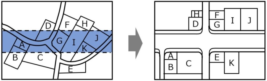
If there are available sites (shown in light gray in the picture below) close to the project area (shown in dark gray), property owners can easily relocate there.
In this case, property ownership can be transferred (or swapped) to that of the relocated site. (See the next chapter for details on how this process works.)
This helps them stay within the same community, making it easier to get their consent.

3. Outlines of the relocation-based programs
There are two relocation-based urban regeneration programs authorized by legislation in Japan.
1) Land Readjustment, 2) Urban Renewal
Essentially, land purchase is not required for these 2 programs.
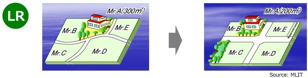
1) Land Readjustment program 【LR】 is a horizontal relocation program;
relocation-based Urban Regeneration method to alter the shape and land conditions of lots and to install or improve public facilities and increase the usage the land.
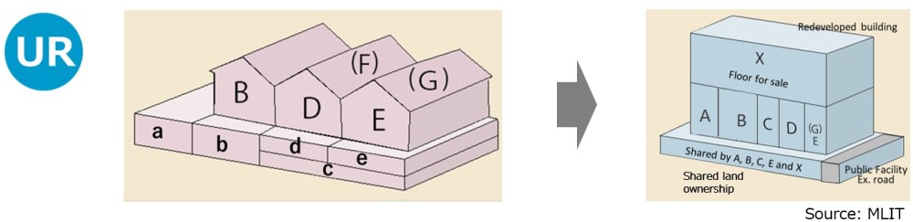
2) Urban Renewal program 【UR】 is a vertical relocation program;
relocation-based method to enhance the efficient land use, urban functions and upgrade the urban resilience through the provision of public facilities and mixed-use fire-proof buildings.
Land Readjustment program
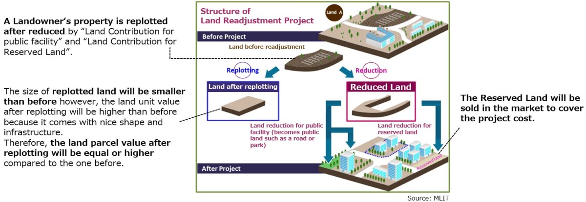
Land Readjustment program is a method to develop public facilities such as roads and parks, and to optimize the shape of the land parcels.
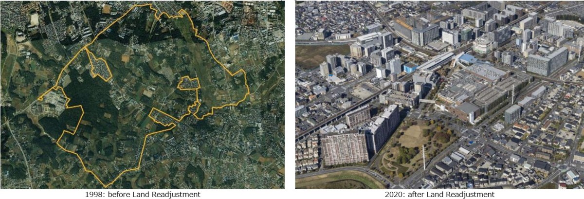
Example of Land Readjustment Program: Nagareyama Otakanomori project developed by UR
1. Scheme of Land Readjustment program
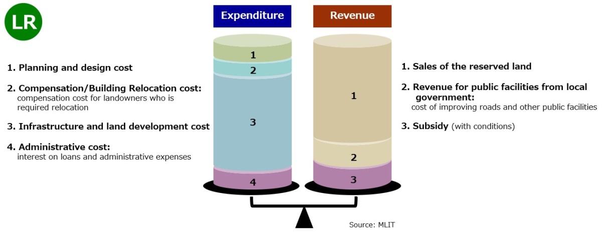
2. Financial Structure of Land Readjustment program
3. Steps of Land Readjustment program
There are 3 major steps as
(1) Urban Planning Approval, (2) Project Plan Approval, (3) Temporally Land Replotting Plan Approval
Project timeline varies by the project, size and conditions.

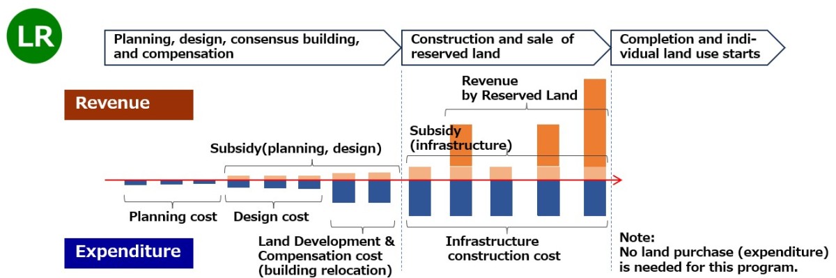
4. Cash Flow in Land Readjustment project
The diagram below shows an example of cash flow during a land readjustment project. Land acquisition costs are not included as expenditures in the cash flow since the Land Readjustment process does not involve purchasing land.
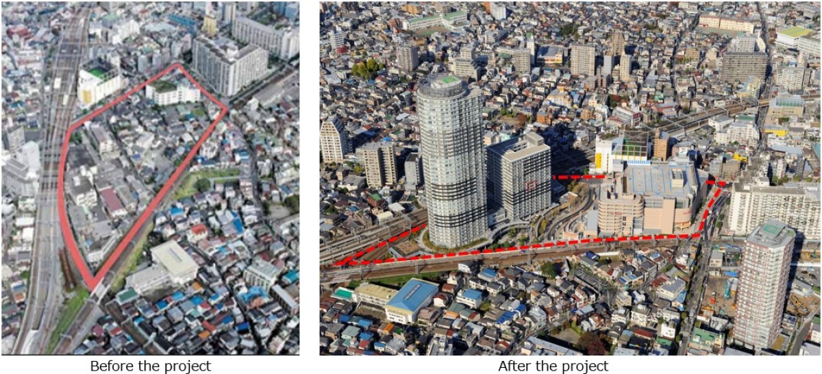
Urban Renewal program
Urban Renewal program is a method to enhance residential environments and update urban functions by promoting the rational land-use, making fire-resistant buildings, and developing public facilities.
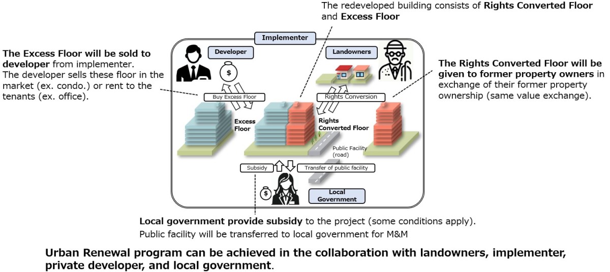
1. Scheme of Urban Renewal program
・The subdivided parcels are consolidated into a large plot, and new building will be built on the land based on property ownership relocation or ”Rights Conversion”.
・A landowner of the property “a” in the left diagram below will get the property “A” in the right diagram as a conversion of property rights (unit ownership). The property A is called “Rights Converted Floor”.
・The property values before and after the project are the same based on the equivalent value exchange, while the property sizes and types are not the same.

2. Financial Structure of Urban Renewal program
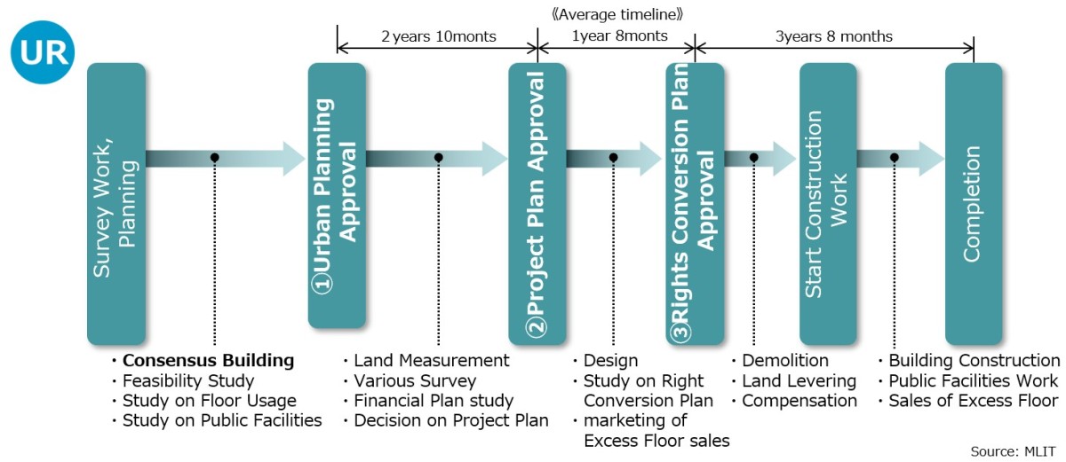
3. Steps of Urban Renewal program
There are 3 major steps as
(1) Urban Planning Approval, (2) Project Plan Approval, (3) Rights Conversion Plan Approval
Construction timeline varies by building height and its volume.
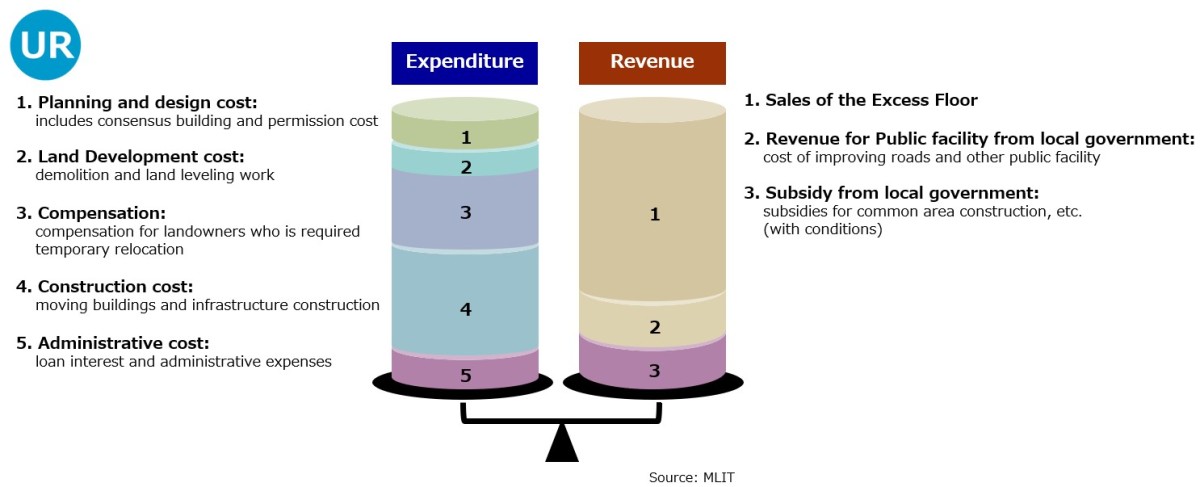
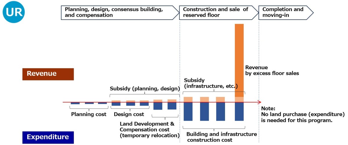
4. Cash Flow in the Urban Renewal project
As with the Land Readjustment process, land acquisition costs are not included as expenditures in the cash flow.
Projects by UR
Land Readjustment projects

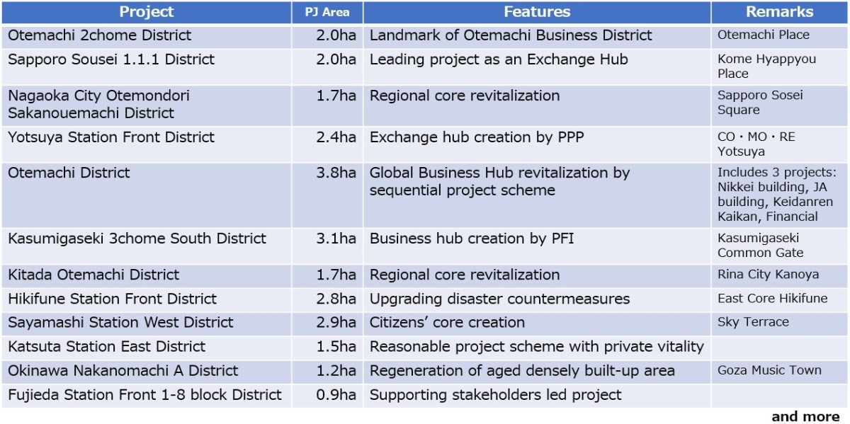
Urban Renewal projects
Reference: Cash flow in the Road Development project with Land Acquisition
